


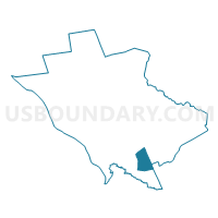
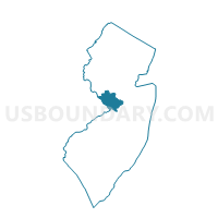
Hamilton township voting district 10, Mercer County, New Jersey
About
Outline

Summary
| Unique Area Identifier | 619494 |
| Name | Hamilton township voting district 10 |
| County | Mercer County |
| State | New Jersey |
| Area (square miles) | 3.72 |
| Land Area (square miles) | 3.72 |
| Water Area (square miles) | 0.00 |
| % of Land Area | 99.96 |
| % of Water Area | 0.04 |
| Latitude of the Internal Point | 40.18843980 |
| Longtitude of the Internal Point | -74.63036690 |
Maps

Graphs
Select a template below for downloading or customizing gragh for Hamilton township voting district 10, Mercer County, New Jersey


Neighbors
Neighoring Voting District (by Name) Neighboring Voting District on the Map
- Hamilton township voting district 3, Mercer County, NJ
- Hamilton township voting district 45, Mercer County, NJ
- Hamilton township voting district 57, Mercer County, NJ
- Hamilton township voting district 61, Mercer County, NJ
- Hamilton township voting district 68, Mercer County, NJ
- Upper Freehold township voting district 2, Monmouth County, NJ
- Washington township voting district 2, Mercer County, NJ
- Washington township voting district 6, Mercer County, NJ
Top 10 Neighboring County Subdivision (by Population) Neighboring County Subdivision on the Map
- Hamilton township, Mercer County, NJ (88,464)
- Robbinsville township, Mercer County, NJ (13,642)
- Upper Freehold township, Monmouth County, NJ (6,902)
Top 10 Neighboring Place (by Population) Neighboring Place on the Map
- Hamilton Square CDP, NJ (12,784)
- Yardville CDP, NJ (7,186)
- Robbinsville CDP, NJ (3,041)
- Groveville CDP, NJ (2,945)
Top 10 Neighboring Elementary School District (by Population) Neighboring Elementary School District on the Map
Top 10 Neighboring Unified School District (by Population) Neighboring Unified School District on the Map
Top 10 Neighboring State Legislative District Lower Chamber (by Population) Neighboring State Legislative District Lower Chamber on the Map
Top 10 Neighboring State Legislative District Upper Chamber (by Population) Neighboring State Legislative District Upper Chamber on the Map
Top 10 Neighboring 111th Congressional District (by Population) Neighboring 111th Congressional District on the Map
Top 10 Neighboring Census Tract (by Population) Neighboring Census Tract on the Map
- Census Tract 43.10, Mercer County, NJ (9,288)
- Census Tract 8119, Monmouth County, NJ (6,902)
- Census Tract 30.03, Mercer County, NJ (6,293)
- Census Tract 30.01, Mercer County, NJ (6,081)
- Census Tract 30.02, Mercer County, NJ (5,717)
- Census Tract 43.09, Mercer County, NJ (4,354)